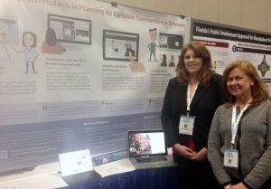
Savannah Edwards and Marcia Scott present at the Transportation Research Board
IPA Policy Scientist Marcia Scott and Public Administration fellow Savannah Edwards (MPA ’17) presented a poster at the 96th Annual Meeting of the Transportation Research Board (TRB) in Washington, D.C. on January 9 and 10, 2017. TRB Session 697, “Current Issues in Transportation Public Involvement.” The poster, entitled “GIS Story Maps Empower and Engage Stakeholders in Planning for Complete Communities in Delaware,” was among the 25 selected for presentation by the TRB Committee on Public Involvement. The poster graphically displays how GIS Story Maps can engage planning stakeholders via both conventional, in-person methods (e.g., public meetings and workshops), and newer, high-tech strategies (e.g., accessing Apps from computers and mobile devices).
Designed by IPA Policy Specialist Sarah Pragg, the 4’ x 8’ poster summarizes research, funded by the Mid-Atlantic Transportation Sustainability University Transportation Center (MATS UTC), which explores the use of GIS Story Maps to satisfy mandates for increased transparency, accountability, and public engagement in planning for transportation-efficient and sustainable places. The final report, GIS Story Maps: A Tool to Empower and Engage Stakeholders in Planning Sustainable Places, is available electronically on IPA’s transportation policy publications webpage.
IPA has developed a series of GIS Story Maps to illustrate Delaware’s complete communities planning framework that is designed to build capacity of local governments to create “attractive, inclusive, efficient, healthy & resilient places.” Each Story Map conveys one of the five elements of a complete community. IPA’s poster is on display on the first floor or University of Delaware’s Graham Hall. IPA’s GIS Story Map Gallery can be viewed online at http://arcg.is/25DcjGV.

